N - Datasets
Granger, S. J., Quincke, J. A., Carswell, A. M., Olde, L., Darch, T., Peukert, S., Horrocks, C. A., Dixon, E. R., Collins, A. L., Blackwell, M. S. A., Murray, P. J., Dungait, J. A. J. and Harris, P. 2023. Water chemistry of combined surface and subsurface runoff from the North Wyke Farm Platform, with hydrologically isolated catchments sown with different pasture types. Rothamsted Research. https://doi.org/10.23637/rothamsted.98v27
Authors | Granger, S. J., Quincke, J. A., Carswell, A. M., Olde, L., Darch, T., Peukert, S., Horrocks, C. A., Dixon, E. R., Collins, A. L., Blackwell, M. S. A., Murray, P. J., Dungait, J. A. J. and Harris, P. |
---|---|
Abstract | 
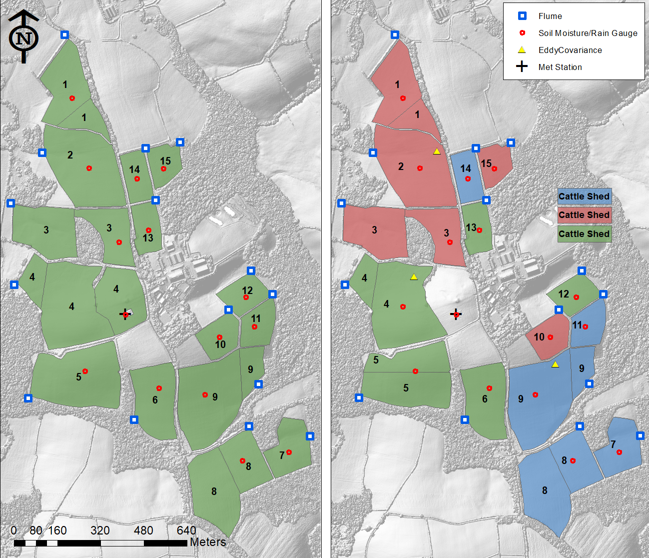
This dataset comprises a number of measurements of water chemistry and water quality taken from the North Wyke Farm Platform (NWFP, Devon, UK) between October 2012 and April 2018. The dataset is an amalgamation of data from a number of experimental campaigns, where water samples from the combined surface and subsurface runoff from hydrologically isolated fields under different pasture types were collected and analysed in the laboratory for water quality measurements. These measurements include dissolved total organic carbon and non-purgeable organic carbon; ammonium, total nitrogen and total oxidisable nitrogen; total and reactive phosphorus; and suspended sediment. Note that this is not a continuous dataset and that not all studies measured the same parameters. Information on sample numbers, dates and laboratory water quality measurements made are given in Summary_of_available_data.csv. The NWFP measures water quality parameters in-situ at water flumes for each of its 15 catchments, in addition to water discharge rate. Environmental measurements such as precipitation and soil moisture at each catchment’s centre are also measured. In-situ flume measurements have been taken at 15-minute intervals continuously since 2012 and are openly available via the NWFP data portal. Such in-situ (proxy) measurements deemed to be most complementary to the laboratory measurements are also provided in the amalgamated dataset, at the 15-minute interval closest to the physical collection of the water for laboratory analysis. Further data and background information are available online, see the related outputs for more information. It is anticipated that this dataset may be used to compare in-situ proxies with laboratory measurements (for example, turbidity and suspended sediment) or for the comparison of in-situ and laboratory measurements of the same analyte. |
Year of Publication | 2023 |
Publisher | Rothamsted Research |
Digital Object Identifier (DOI) | https://doi.org/10.23637/rothamsted.98v27 |
Keywords | sown grasslands |
nitrogen | |
phosphorus | |
carbon | |
turbidity | |
sediment | |
Publication dates | |
Online | Jan 2023 |
Funder | Biotechnology and Biological Sciences Research Council |
CIEL | |
Natural Environment Research Council | |
Lawes Agricultural Trust | |
University of Reading | |
The Stapledon Memorial Trust | |
Related Output | |
Is described by | http://resources.rothamsted.ac.uk/sites/default/files/groups/North_Wyke_Farm_Platform/FP_UG.Doc_.002_15MinData_ver1.10.pdf |
Is described by | http://resources.rothamsted.ac.uk/sites/default/files/groups/North_Wyke_Farm_Platform_National_Capability/DataPortal/Hydrological%20Incontinence%20at%20Catchment%2012%20%28Dairy%20North%29.pdf |
Is supplemented by | http://resources.rothamsted.ac.uk/farm-platform-national-capability/data-collections |
Is supplemented by | https://rres-td.shinyapps.io/Suspended_sediment_versus_turbidity_rating_curves/ |
Continues | https://doi.org/10.23637/rothamsted.98q74 |
Has metadata | https://doi.org/10.1111/ejss.12351 |
Has metadata | https://doi.org/10.2134/jeq2014.04.0193 |
Has metadata | https://doi.org/10.5194/hess-2017-684 |
Funder project or code | The North Wyke Farm Platform [2012-2017] |
The North Wyke Farm Platform- National Capability [2017-22] | |
S2N - Soil to Nutrition - Work package 2 (WP2) - Adaptive management systems for improved efficiency and nutritional quality | |
S2N - Soil to Nutrition - Work package 3 (WP3) - Sustainable intensification - optimisation at multiple scales | |
Roots for the future- A systematic approach to root design (SUREROOT) (BBSRC-LINK) | |
Data files | Copyright license CC BY 4.0 Data type Spreadsheet Contents Data File Access Level Open |
Data files | Copyright license CC BY 4.0 Data type Spreadsheet Contents Documentation File Access Level Open |
Data files | Copyright license CC BY 4.0 Data type Spreadsheet Contents Additional metadata File Access Level Open |
Data files | Copyright license CC BY 4.0 Data type Image Contents Additional metadata File Access Level Open |
Data files | Copyright license CC BY 4.0 Data type Text Contents Documentation File Access Level Open |
Data collection period | 01 Oct 2012 to end of 30 Apr 2018 |
Geographic location | N50.769527, W3.901542, Devon, SW England, UK |
Data collection method | This dataset contains water quality information of combined surface and subsurface runoff, taken from catchments on the NWFP. The NWFP is separated into three self-contained farms (“farmlets”) which are managed according to different operational philosophies or practices, and these farming systems are updated periodically. During the period over which this dataset was collected, the three 22ha farmlets were all pasture based and used for livestock production in the form of a beef herd and sheep flock. From 2010 to between 2013 and 2015 (depending on the catchment) the farmlets were all under permanent pasture (map 1 in figure) and are referred to as the ‘baseline’ period in the Treatment column of the data. The first system change period (2013/5 to 2019, map 2 in figure) was either a reseed with innovative grass species with desirable traits (‘reseed’ in the Treatment column of the data), reseeded with a mixture of white clover and the same innovative grass species (‘legumes’), or continued permanent pasture (‘permanent pasture’). The catchments of the NWFP are hydrologically isolated, and the highly impermeable subsoil means that water moving as surface or subsurface runoff is captured by a bounding drainage system and directed towards a flume, with one flume per catchment. Each farmlet consists of five catchments (with each consisting of one or two fields) and are highly instrumented and monitored, allowing the collection of a wide variety of environmental data to complement agricultural production data. Core NWFP datasets are open and include in-situ water flow and chemistry taken at 15-minute intervals; 15-minute Met measurements; 15-minute soil moisture measurements; 30-minute GHG emissions; soils, crop and botanical field survey data; livestock and crop performance data; and farm operational activities (see related output). |
Data preparation and processing activities | In addition to the experimental data, where the water quality was assessed in the lab, in-situ data (available via the NWFP data portal, see related information for the link) have been included where they were felt to complement the dataset. As some measurements were made both in the lab and in-situ, column names include the subscripts ‘_lab’ or ‘_portal’ for clarity. In-situ data includes discharge (flow) rate, conductivity, dissolved organic matter, ammonium, ammonia, nitrogen oxides, pH, reactive and total phosphorus, turbidity, flume temperature and precipitation, where available. However, as in-situ measurements cannot be performed at very low flows, there are gaps in this in-situ data. Users should note that the manual samples were taken on no particular schedule (recorded in Datetime_lab) and are matched with the closest in-situ measurement, identified in Datetime_portal. Therefore, potentially there could be an error of up to 7.5 minutes between the two, although typically it is far less than this. |
Permalink - https://repository.rothamsted.ac.uk/item/98v27/water-chemistry-of-combined-surface-and-subsurface-runoff-from-the-north-wyke-farm-platform-with-hydrologically-isolated-catchments-sown-with-different-pasture-types